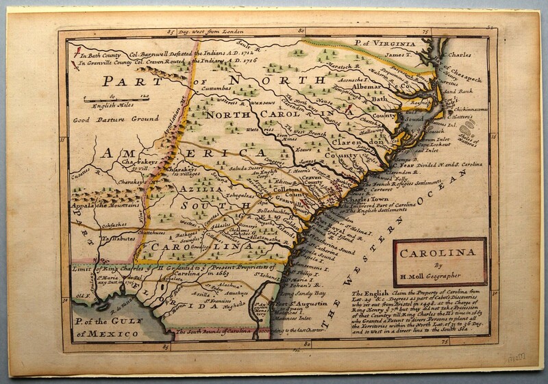
Carolina
Dublin Core
Title
Carolina
Subject
North Carolina--Maps
Description
Hand-colored engraved map: Carolina. By H. Moll Geographer [Cartouche, lower right] | The English claim the Property of Carolina from Lat. 29 &c. Degrees as part of Cabot’s Discoveries who set out from Bristol in 1498, at the Charge of King Henry ye 7th but they did not take Possession of that Country till King Charles the ii’s time in 1663 who Granted a Patent to divers Persons to plant all the Territories within North Lat. Of 31 to 36 Deg. and so west in a direct line to the South Sea. [below cartouche] | The destruction of “St. Maria de Palaxy” on the Gulf is noted as are Col. Barnwell’s defeat of the Indians in North Carolina in 1712 and Col. Craven’s victory in 1716.
This map, which extends from “The South Bounds of Carolina” to “C. Charles” in Virginia, shows the locations of Indian tribes in the Carolinas. It also gives the chief roads or trading routes westward from “Charles Town” [Charleston]. Many islands along the coast are identified by name for the first time on a printed map. First published in Herman Moll’s Atlas Minor (London, 1729), Plate 50, the map appeared with variations in subsequent editions of the book through the 1760s. In issues of the map after 1732, the date has been deleted as it is on this example.
Dutch-born Herman Moll (? – 1732) was in England by about 1680 or soon thereafter He was England’s most prolific designer and publisher of maps of Carolina in the first third of the eighteenth century. He began as a mapmaker for others and soon began publishing his own compilations and atlases. His cartographical style is distinctive; he combines a rather blunt clarity of lettering and considerable detail without flourishes or extraneous design. He frequently scatters short explanatory legends over his map. Although Moll died in 1732, his maps and atlases continued to be published, with revisions, during most of the eighteenth century.
Purchase; funds donated by the North Carolina Chapter, General Society of Colonial Wars.
Creator
Moll, Herman
Source
Tryon Palace
Publisher
Moll, Herman
Date
1736?
Rights
Permission to use the photograph must be obtained in writing from Tryon Palace Historic Sites & Gardens, New Bern, North Carolina. It must be accompanied by the caption” From the collection of Tryon Palace Historic Sites & Gardens, New Bern, North Carolina; North Carolina Department of Cultural Resources, Division of Archive and History.”
Format
jpg
Language
English
Type
Maps
Identifier
TP.1989.006.001
Coverage
North Carolina
Still Image Item Type Metadata
Original Format
Maps
Physical Dimensions
Paper: 8 7/8” X 13 1/8”
Plate: 8” X 11 1/8”
Image: 7 7/8” X 10 ¾”
Plate: 8” X 11 1/8”
Image: 7 7/8” X 10 ¾”
Collection
Citation
Moll, Herman, “Carolina,” Craven County Digital History, accessed February 4, 2026, https://kellenberger.mycprl.org/digital/items/show/631.
Position: 61 (115 views)
